Схема Главных Дорог Римской Империи напоминает карту Нью-Йоркского метро. Но разветвленнее
Опубликовано 2017-06-19 16:00 , обновлено 2022-12-10 14:03

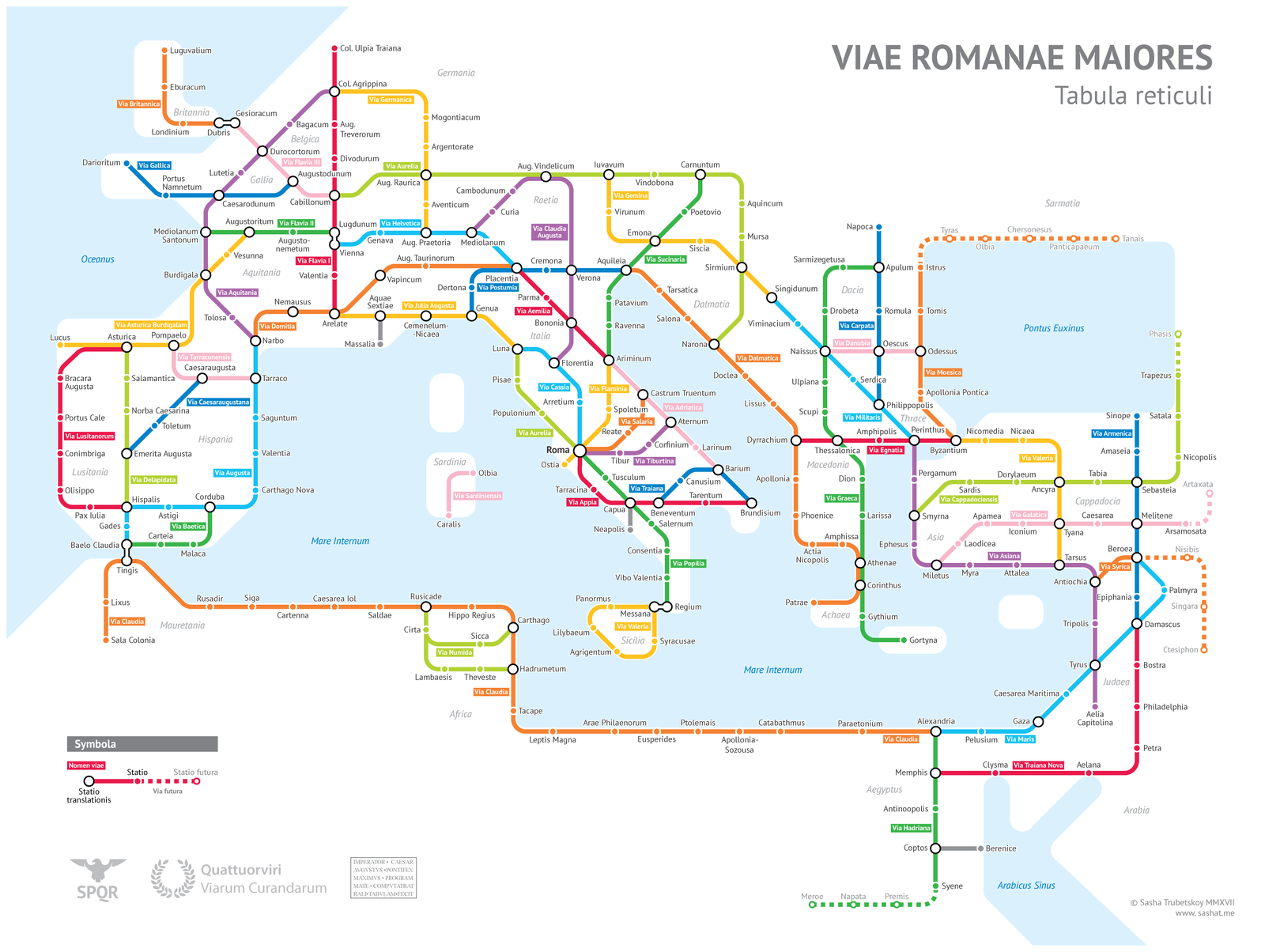
It’s finally done. A subway-style diagram of the major Roman roads, based on the Empire of ca. 125 AD.
Creating this required far more research than I had expected—there is not a single consistent source that was particularly good for this. Huge shoutout to: Stanford’s ORBIS model, The Pelagios Project, and the Antonine Itinerary (found a full PDF online but lost the url).
The lines are a combination of actual, named roads (like the Via Appia or Via Militaris) as well as roads that do not have a known historic name (in which case I creatively invented some names). Skip to the “Creative liberties taken” section for specifics.
How long would it actually take to travel this network? That depends a lot on what method of transport you are using, which depends on how much money you have. Another big factor is the season – each time of year poses its own challenges. In the summer, it would take you about two months to walk on foot from Rome to Byzantium. If you had a horse, it would only take you a month.
However, no sane Roman would use only roads where sea travel is available. Sailing was much cheaper and faster – a combination of horse and sailboat would get you from Rome to Byzantium in about 25 days, Rome to Carthage in 4-5 days. Check out ORBIS if you want to play around with a “Google Maps” for Ancient Rome. I decided not to include maritime routes on the map for simplicity’s sake.
Creative liberties taken
The biggest creative element was choosing which roads and cities to include, and which to exclude. There is no way I could include every Roman road, these are only the main ones. I tried to include cities with larger populations, or cities that were provincial capitals around the 2nd century.
Obviously to travel from Petra to Gaza you would take a more or less direct road, rather than going to Damascus and “transferring” to the Via Maris. The way we travel on roads is very different from rail, which is a slight flaw in the concept of the map. But I think it’s still aesthetically pleasing and informative.
Here’s a list of the roads that have authentic names and paths:
- Via Appia
- Via Augusta
- Via Aurelia
- Via Delapidata
- Via Domitia
- Via Egnatia
- Via Flaminia
- Via Flavia (I, II, III)
- Via Julia Augusta
- Via Lusitanorum
- Via Militaris
- Via Popilia
- Via Portumia
- Via Salaria
- Via Tiburtina
- Via Traiana
- Via Traiana Nova
Some roads have real names but were modified somewhat:
- The Via Latina I combined with the Via Popilia. In reality the Popilia ended at Capua, and the Latina went from Capua to Rome.
- Via Aquitania only referred to the road from Burdigala (Bordeaux) to Narbo (Narbonne).
- Via Asturica Burdigalam similarly only refers to the Astrurica-Burdigala section.
- “Via Claudia” is not a real name, but refers to a real continuous road built by Claudius.
- Via Hadriana was a real road in Egypt, but it refers to a slightly different section than the green route.
- The name “Via Maris” is considered to be a modern creation, referring to real ancient trade road whose real name has been lost to history.
- Via Valeria only referred to a section of the yellow Sicilian loop.
- The roads around Pisae, Luna and Genua had several names for different sections, including Via Aemilia Scauri. Sometimes “Via Aurelia” referred to the entire road from Rome to Arelate.
- Via Sucinaria is the Latin name for the Amber Road, a trade route from the Baltic region to Italy that carried amber as a valuable good. It probably was not used to refer to a single literal road.
- Via Gemina and Via Claudia Augusta are real names that referred to small parts of the routes marked on the map.
The other roads have relatively uncreative names that I invented, usually based on a place that they pass through. I have never formally studied Latin and I’ll admit that I am somewhat confused by the distinction between -a and -ensis endings, so there’s a chance I may have messed that up.
As questions come up I will update this section.
Читайте также:
Для русскоязычного человечества существование второго третьего Рима Турции является сюрпризом. Так же как для турецкоязычного человечества существование третьего Рима России является абсурдном и самозванством.
Диктатор Рима Луций Корнелий Сулла прибавил к своему имени слово «Феликс», что значит «счастливчик». После страшной смерти добиться царских почестей — это ли не удача?
«После этой битвы началось всемирное владычество римлян»
|
Оставлять комментарии могут только зарегистрированные пользователи. Войдите в систему используя свою учетную запись на сайте: |
||